

santa clara · santa clara county
Santa Clara Real Estate & Neighborhood Guide
Santa Clara covers 18.3 square miles of the Santa Clara Valley floor in the middle of Silicon Valley, bordered by San Jose on almost every side and by Sunnyvale and Cupertino on the west. It grew up around Mission Santa Clara de Asís, founded in 1777, and Santa Clara College, now Santa Clara University, founded in 1851; the town incorporated on July 5, 1852. It stayed a farm town of under 7,000 people until the 1940s, then boomed: the census counted 11,702 residents in 1950 and 58,880 in 1960. City parcel data date about 81% of today's roughly 16,000 single-family houses to 1950-69. Those houses are a minority of the 50,229 homes counted in 2020; apartments, townhomes and condominiums make up the rest.
population, 2020 census
land area
zip codes
incorporated
1030 Pomeroy Avenue, Santa Clara, CA 95051
Single Family Home 5 Beds 3 Baths 2,186 SqFt
Listed by Boyenga Team of Boyenga Team / Compass3679 De La Cruz Blvd, Santa Clara, CA 95054
Single Family Home 4 Beds 3 Baths 1,865 SqFt
Listed by Boyenga Team of Boyenga Team / Compass560 Mission St, Santa Clara, CA 95050
Single Family Home 3 Beds 2 Baths 1,414 SqFt
Listed by Eric & Janelle Boyenga of Boyenga Team / Compass855 Monroe Street, Santa Clara, CA 95050
Single Family Home 3 Beds 2.5 Baths 1,757 SqFt
Listed by Boyenga Team of Boyenga Team / Compass2276 Lenox Pl, Santa Clara, CA 95054
Single Family Home 3 Beds 2.5 Baths
Listed by Boyenga Team of Boyenga Team / Compass819 Harrison St, Santa Clara, CA 95050
Multi-Family 4 Beds 2 Baths 1,676 SqFt
Listed by Boyenga Team of Boyenga Team / Compass2040 Main ST 135, Santa Clara, CA 95050
Condo 2 Beds 2.5 Baths 1,125 SqFt
Listed by Boyenga Team of Compass
478 N Winchester Blvd #8, Santa Clara, CA 95050
Condo 2 Beds 2 Baths 1,031 SqFt
Listed by Boyenga Team of Boyenga Team / Compass3444 Kenyon DR, Santa Clara, CA 95051
Single Family Home 3 Beds 2 Baths 1,592 SqFt
Listed by Graeham Watts of Compass471 Lowell DR, Santa Clara, CA 95051
Single Family Home 3 Beds 2 Baths 1,284 SqFt
Listed by Edna Eng of Compass2640 Monroe ST, Santa Clara, CA 95051
Single Family Home 3 Beds 2 Baths 1,742 SqFt
Listed by Lila Kazemi of Compass1341 Los Padres BLVD, Santa Clara, CA 95050
Single Family Home 4 Beds 3 Baths 2,006 SqFt
Listed by Paul Besse of Compass1970 Briarwood DR, Santa Clara, CA 95051
Single Family Home 3 Beds 2 Baths 1,212 SqFt
Listed by Damon Holst of Compass3079 El Camino Real 205, Santa Clara, CA 95051
Condo 3 Beds 3.5 Baths 1,797 SqFt
Listed by Bernie Romero of Toll Brothers Real Estate,Inc
3079 El Camino Real 210, Santa Clara, CA 95051
Condo 3 Beds 3 Baths 1,712 SqFt
Listed by Bernie Romero of Toll Brothers Real Estate,Inc3079 El Camino Real 208, Santa Clara, CA 95051
Condo 3 Beds 3 Baths 1,544 SqFt
Listed by Bernie Romero of Toll Brothers Real Estate,Inc1095 Buchanan CT, Santa Clara, CA 95051
Single Family Home 3 Beds 2 Baths 1,329 SqFt
Listed by Todd Wiley of Compass
3578 Rambla PL #316, Santa Clara, CA 95051
Condo 1 Bed 1 Bath 936 SqFt
Listed by In Hee Reena Kim of Coldwell Banker Realty1750 Halford Ave 211, Santa Clara, CA 95051
Condo 2 Beds 2 Baths 983 SqFt
Listed by Praveen Bhardwaj of eXp Realty of Northern California, Inc121 Buckingham Dr 25, Santa Clara, CA 95051
Condo 2 Beds 2 Baths 1,137 SqFt
Listed by Kanwal Gill of Keller Williams Realty
CA Santa Clara
Santa Clara
Santa Clara Real Estate & Homes for Sale
Living in Santa Clara
Santa Clara is a city of about 128,000 people (2020 census) on about 18 square miles in the middle of Silicon Valley. The town grew up around Santa Clara University and incorporated in 1852, then filled in with tract houses in the 1950s and 1960s. Today it mixes those ranch-house streets with townhomes, condos and apartments.
Santa Clara Neighborhoods
Neighborhoods include the Old Quad around the university, Monastery Gardens, Westwood, Forest Park, Central Park West with Eichler’s Pomeroy Green and Pomeroy West, Westwood Oaks, Briarwood, Bowers/Monroe, Lawrence Station, Fairway Glen and Rivermark.
Schools
Most of Santa Clara is in the Santa Clara Unified School District. A band along the south edge near Stevens Creek Boulevard is in Cupertino Union and Fremont Union to the west and Campbell Union and Campbell Union High to the east. Confirm boundaries for a specific home before you buy.
Downtown & Lifestyle
Central Park and its library sit in the middle of the city, Levi’s Stadium and California’s Great America are in the north, and Santa Clara University and the Triton Museum of Art are near downtown.
Commute
Caltrain stops at the Santa Clara Transit Center downtown, VTA light rail runs along Tasman Drive in the north, and US 101, I-280, I-880 and Highway 237 are all close, with Central, Lawrence, San Tomas and Montague expressways across town.
Buying or Selling in Santa Clara
From 1950s ranch houses to Rivermark townhomes, the Boyenga Team / Compass works across Santa Clara. Call Eric & Janelle Boyenga at (408) 373-1660 or (650) 383-8606, or send us a message below.
Listings
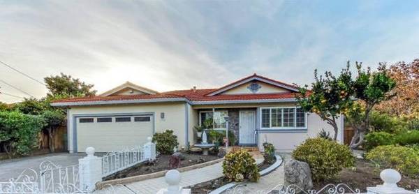 5 Beds 3 Baths 2,186 SqFt$1,598,000Active
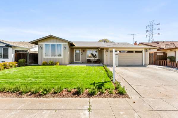 4 Beds 3 Baths 1,865 SqFt$1,489,000Active
- 1/24 24
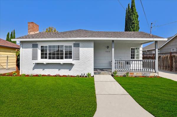 3 Beds 2 Baths 1,414 SqFt$1,398,000Active
neighborhoods
Santa Clara neighborhoods
Santa Clara's neighborhoods read like a timeline. The oldest houses are around Santa Clara University and the downtown grid known as the Old Quad. Most of the rest of the city is 1950s and early-1960s tract housing: city parcel data date about 62% of single-family houses to the 1950s and 19% to the 1960s, about 91% are one story, and the median lot is about 5,660 square feet. Builders recorded those tracts in small units with names like El Rancho Camino, Bowers Park, Briarwood, Westwood Oaks and Maywood, and many MLS area names come straight from them. Joseph Eichler's company added two attached communities, Pomeroy Green (78 two-story townhomes, run as a cooperative) and Pomeroy West (138 homes in a condominium community). Townhome tracts followed in the 1970s; Rivermark, a planned community of townhomes, small-lot houses, condos and apartments, went up in the 2000s on the former Agnews hospital west campus; and the newest districts are being built under specific plans such as the 2016 Lawrence Station Area Plan next to Lawrence Caltrain and the Tasman East plan near Levi's Stadium.
Old Quad
Santa Clara's original town: the angled street grid around Santa Clara University and the old downtown, where 1860s to 1920s cottages and bungalows share blocks with postwar tracts and newer townhomes.
Monastery Gardens
A small postwar tract just east of Scott Boulevard, mapped in 1946 and 1952: about 190 mostly one-story houses on Carmel Way, Chapel Drive, Inverness Avenue and the streets around them.
Westwood
A 1952 to 1955 tract of one-story houses between Saratoga Avenue and Winchester Boulevard south of Newhall Street, built out in ten units around Westwood Elementary and Everett Alvarez Jr. Park.
Forest Park
A 1959 to 1962 tract of 371 lots along Kiely Boulevard between Forbes and Pruneridge avenues, with tree-named streets, one- and two-story houses and a school district line at Pruneridge.
Central Park West
The postwar blocks between Homestead Road and El Camino Real, from Lawrence Expressway to Kiely Boulevard, built around Eichler's Pomeroy Green co-op and Pomeroy West condos.
Killarney Farms
Early-1960s ranch streets named for colleges, from Cornell Drive to Vanderbilt Way, south of Homestead Road between Lawrence Expressway and Kiely Boulevard.
Westwood Oaks
Santa Clara's late-1950s pocket west of Lawrence Expressway, between Homestead Road and I-280 on the Cupertino line, where most homes are in Cupertino Union and Fremont Union schools.
Briarwood
Mid-1950s ranch streets north of El Camino Real between Lawrence Expressway and Bowers Avenue, with Briarwood Elementary, Machado Park and Wilcox High inside and Lawrence Caltrain under a mile north.
Bowers/Monroe
About 2,640 mostly single-story 1950s houses on 5,000 to 7,000 sq ft lots around the Bowers Avenue and Monroe Street crossroads, between El Camino Real and the Walsh Avenue industrial blocks.
Lawrence Station
Santa Clara's newest neighborhood: a former industrial park between Kifer Road and Central Expressway, rezoned in 2016 for up to 3,500 homes, next to the Lawrence Caltrain station.
Fairway Glen
North Santa Clara's 1960 ranch-house tract, plus 1970s homes and townhomes and 1990s apartments, between Lafayette Street, Tasman Drive, Lick Mill Boulevard and Hope Drive, half a mile from Levi's Stadium.
Rivermark
A planned community built from 2002 on 152 acres of the former Agnews hospital west campus: townhomes, small-lot houses, condos and apartments around a shopping village, a TK-8 school, a library and parks.
schools
Santa Clara public schools
Elementary and middle
- Santa Clara Unified School District. TK-12 for about 89% of the city's parcels in the city's parcel data, including all of north Santa Clara, plus parts of Sunnyvale, San Jose and Cupertino. District campuses inside the city include elementary schools such as Bowers, Bracher, Briarwood, Hughes, Montague and Pomeroy and the TK-8 Don Callejon School.
- Cupertino Union School District. K-8 for a band along the southwest edge, roughly between Stevens Creek Boulevard and Pruneridge Avenue from the western city line east to about San Tomas Expressway (about 1,700 single-family homes in the city's parcel data).
- Campbell Union School District. K-8 for a smaller band in the southeast, roughly between Stevens Creek Boulevard and Pruneridge and Forest avenues east of San Tomas Expressway (about 520 single-family homes).
High school
- Santa Clara Unified School District. Most of the city. District high schools in Santa Clara include Santa Clara High (3000 Benton Street), Adrian Wilcox High (3250 Monroe Street) and Mission Early College High at Mission College; Kathleen MacDonald High, opened in 2022, is on the district's Agnews campus in San Jose.
- Fremont Union High School District. The southwest band that is in Cupertino Union for the lower grades.
- Campbell Union High School District. The southeast band that is in Campbell Union for the lower grades.
property nerd note
Santa Clara's school map does not follow the city limit or the ZIP codes. Most addresses are in Santa Clara Unified, but the band along the south edge near Stevens Creek Boulevard is split between Cupertino Union with Fremont Union to the west and Campbell Union with Campbell Union High to the east, and a handful of parcels at the east edge are in San Jose Unified. For any address, confirm the district first, then the assigned schools with that district. Boundaries change, so check before you write an offer, not after. Start with our Silicon Valley schools guide.
zip codes
Santa Clara ZIP codes
Central and east Santa Clara, east of San Tomas Expressway and south of US 101: downtown and the Old Quad around Santa Clara University, the Civic Center, and the neighborhoods south toward Stevens Creek Boulevard and Westfield Valley Fair.
West Santa Clara, west of San Tomas Expressway, from Stevens Creek Boulevard north past El Camino Real to Central Expressway: Central Park, Bowers/Monroe, Briarwood, Westwood Oaks and Lawrence Station.
North Santa Clara, roughly north of US 101: Mission College, California's Great America, Levi's Stadium and the Convention Center, Fairway Glen and Rivermark.
RECENTLY SOLD LISTINGS

$2,320,000
Single Family Home
385 Cronin DR, Santa Clara, CA 95051
Stunning updated Mackay home in the highly sought-after Maywood Park neighborhood, just steps from Maywood Park and Eise...
Listed by Boyenga Team of Compass

$2,320,000
Single Family Home
385 Cronin DR, Santa Clara, CA 95051
Stunning updated Mackay home in the highly sought-after Maywood Park neighborhood, just steps from Maywood Park and Eise...
Listed by Boyenga Team of Compass

$2,827,500
Single Family Home
748 Clara Vista AVE, Santa Clara, CA 95050
Experience refined luxury in this stunning, newly built contemporary home in the heart of Santa Clara. Bright, airy, and...
Listed by Boyenga Team of Compass
MARKET TRENDS

listing detail
getting around
Getting around Santa Clara
Caltrain and regional trains
Santa Clara station is part of the downtown Santa Clara Transit Center by Santa Clara University. Caltrain Local and Limited trains stop there (Express trains pass through), along with ACE trains to Stockton and Capitol Corridor trains to Auburn, and VTA buses 21, 22, 53, 59, 60 and Rapid 522 connect; Route 60 runs to the airport. The station is the planned end of BART's Silicon Valley extension, and its 1863 depot now houses the Edward Peterman Museum of Railroad History. Lawrence station is just over the western line in Sunnyvale, and Santa Clara-Great America station in the north (opened 1993) serves ACE and Capitol Corridor trains.
Light rail
VTA's Orange Line (Mountain View to Alum Rock) and Green Line run along Tasman Drive in north Santa Clara, stopping at Old Ironsides, Great America and Lick Mill stations. Lick Mill is the recommended transfer to the Santa Clara-Great America train station, about a fifth of a mile away, and it closes for up to an hour after Levi's Stadium events.
Freeways and expressways
US 101 crosses the north-center of the city, Highway 237 runs along its north tip, I-880 passes just east of the city and I-280 clips its southwest corner. Central, Lawrence, San Tomas and Montague expressways and El Camino Real (State Route 82) carry most cross-town traffic.
Buses and the airport
San Jose Mineta International Airport is next door on the city's east side, and VTA Route 60 runs to it from the Santa Clara Transit Center. Main bus corridors include El Camino Real (22 and Rapid 522), Monroe Street (21), Bowers Avenue and Kiely Boulevard (57) and Agnew Road and Montague Expressway (20, to Milpitas BART).
living here
Living in Santa Clara
Central Park and the library
Central Park covers about 40.6 acres at 909 Kiely Boulevard in the city's park GIS, and the Central Park Library is next to it at 2635 Homestead Road. Santa Clara runs its own city library, separate from the county library district, with the Mission branch (1098 Lexington Street) and the Northside branch in Rivermark (695 Moreland Way).
Parks and pools
The city's park GIS maps more than 50 city park and recreation sites, from Nuevo's half-acre pocket parks at Lawrence Station to neighborhood parks such as Bowers (7.6 acres), Maywood (7.3) and Live Oak (10.2), plus city pools at Warburton Park, Mary Gomez Park and the Montague Swim Center.
Santa Clara University and museums
Santa Clara University, founded as Santa Clara College in 1851, anchors the east side next to downtown. Its de Saisset Museum, open to the public free of charge, holds nearly 10,000 artworks and historical objects. Across from the Civic Center, the Triton Museum of Art at 1505 Warburton Avenue, in its current building since 1987, shows contemporary and historical work with a focus on Bay Area artists.
Levi's Stadium and the convention district
Levi's Stadium, home of the San Francisco 49ers since 2014 with about 68,500 seats, sits on Tasman Drive beside the Santa Clara Convention Center; it hosted Super Bowl LX in February 2026 and matches of the 2026 FIFA World Cup. Across the street, the city has approved City Place Santa Clara on about 240 acres at 5155 Stars and Stripes Drive, the site of the Santa Clara Golf and Tennis Club.
Mission College and Great America
North of US 101, Mission College, a public community college that opened in 1975 and hosts exhibits in its Vargas Gallery, shares the area with California's Great America, a 112-acre amusement park open since 1976.
Trails and creeks
The San Tomas Aquino/Saratoga Creek Trail follows the creek from Monroe Street north past Levi's Stadium toward the Bay, and the 40-acre Ulistac Natural Area, maintained by volunteers, lies between Lick Mill Boulevard and the Guadalupe River with seven natural habitat areas.
your santa clara team
Buy or sell in Santa Clara with the Boyenga Team
Eric and Janelle Boyenga and the Property Nerds® at Compass have sold more than 2,520 Silicon Valley homes, $2.6+ billion in all, since 1996. We know Santa Clara block by block, from pricing and prep to the off-market homes most buyers never see.
Search Santa Clara homes Get my home value (408) 373-1660 (650) 383-8606
how we help
Property Nerds® in Santa Clara
Pricing from the data
We compare recent sales street by street, adjusting for lot, condition, schools and style, so you buy or list at a price the market will support.
Prep that pays
Selling? We focus prep money where Santa Clara buyers notice it. Compass Concierge can start eligible work with nothing due upfront.
See homes first
Buying? Compass Private Exclusives and our network show you homes before they reach the public sites.
faq
Santa Clara real estate FAQ
What ZIP codes does Santa Clara use?
Homes are in 95050 (central and east, east of San Tomas Expressway), 95051 (west of San Tomas Expressway) and 95054 (north Santa Clara, roughly north of US 101). 95053 is the Santa Clara University campus.
Which school districts serve Santa Clara?
Santa Clara Unified covers most of the city for TK-12. A band along the south edge near Stevens Creek Boulevard is in Cupertino Union and Fremont Union (west) or Campbell Union and Campbell Union High (east). Check every address with the districts, since boundaries change.
Who supplies electricity in Santa Clara?
The city owns its electric utility, Silicon Valley Power, which serves Santa Clara; its Donald Von Raesfeld power plant came online in 2005. Ask a seller for recent utility bills to see actual costs.
Where does Caltrain stop in Santa Clara?
At Santa Clara station in the downtown Santa Clara Transit Center, where ACE and Capitol Corridor trains and many VTA buses also stop. Lawrence station is just over the line in Sunnyvale, and north Santa Clara has light rail on Tasman Drive and the Santa Clara-Great America train station.
When were most Santa Clara neighborhoods built?
Mostly in the 1950s and 1960s. The census counted 11,702 residents in 1950 and 58,880 in 1960, and city parcel data date about 81% of single-family houses to 1950-69. Newer areas include 1970s townhome tracts, Rivermark (2000s) and the Lawrence Station and Tasman East districts now being built.
More Property Nerd guides: Palo Alto Los Altos Redwood City Menlo Park Mountain View Cupertino Sunnyvale Los Gatos Campbell Saratoga San Carlos Belmont San Mateo Burlingame San Francisco Atherton Los Altos Hills Monte Sereno Woodside Portola Valley San José neighborhoods Silicon Valley schools

Coming Soon
Commute Score
Coming Soon
Coming Soon
demographics
Population:
Density:
Households:
Gender
Coming Soon
Coming Soon
Coming Soon
Coming Soon
more santa clara neighborhood guides
Neighborhood guides in Santa Clara
See every guide in the Nerd Portal.

Eric & Janelle Boyenga
homes@boyenga.com