

redwood city · san mateo county
Redwood City Real Estate & Neighborhood Guide
Redwood City runs from San Francisco Bay to the foothills: Redwood Shores, built partly on former salt ponds behind levees east of Highway 101; Bair Island and the port along Redwood Creek; downtown around the county courthouse; flat grid neighborhoods between El Camino Real and Alameda de las Pulgas; and hillside streets climbing toward I-280. It started as a lumber landing. The library's local history says a deep-water channel up what is now Redwood Creek was found in 1851 and used to ship wood to San Francisco, and an 1857 election made the town the county seat. The city counts 1867 as its incorporation year, chartered its port in 1937 and agreed in 1959 to annex the land that became Redwood Shores. The 2020 census counted 32,373 housing units.
population, 2020 census
land area
zip codes
incorporated
1200 Stockbridge Ave, Redwood City, CA 94061
Single Family Home 6 Beds 5.5 Baths 4,320 SqFt
Listed by Eric & Janelle Boyenga of Boyenga Team / Compass1758 Stockbridge Ave, Redwood City, CA 94061
Single Family Home 6 Beds 4.5 Baths 3,836 SqFt
Listed by Boyenga Team of Boyenga Team / Compass1758 Stockbridge Ave, Redwood City, CA 94061
Single Family Home 6 Beds 4.5 Baths 3,836 SqFt
Listed by Boyenga Team of Boyenga Team / Compass2756 Massachusetts Avenue, Redwood City, CA 94061
Single Family Home 3 Beds 2 Baths 1,400 SqFt
Listed by Boyenga Team of Boyenga Team / Compass1248 Woodside RD, Redwood City, CA 94061
Condo 2 Beds 2 Baths 1,360 SqFt
Listed by Brandon Stovall of Compass
1832 Anamor ST, Redwood City, CA 94061
Single Family Home 3 Beds 2 Baths 1,180 SqFt
Listed by Maria Segal of Compass1548 Hudson ST, Redwood City, CA 94061
Multi-Family 16,059 SqFt
Listed by Matthew Flaherty of Colliers International
40 Palomar Oaks LN, Redwood City, CA 94062
Single Family Home 5 Beds 6 Baths 4,740 SqFt
Listed by Susan Ferguson of Coldwell Banker Realty577 California WAY, Redwood City, CA 94062
Vacant Land
Listed by Timothy A Graffigna of Golden Gate Sotheby's International Realty1714 Whipple AVE, Redwood City, CA 94062
Single Family Home 4 Beds 4 Baths 2,456 SqFt
Listed by Sonny Tang of Corcoran Icon Properties31 Cadiz CIR, Redwood City, CA 94065
Single Family Home 3 Beds 2 Baths 1,560 SqFt
Listed by Brandon Brown of BayBrook Realty
348 Redwood AVE, Redwood City, CA 94061
Single Family Home 4 Beds 3 Baths 1,700 SqFt
Listed by David T Chan of JODI Group59 CV, Redwood City, CA 94065
Condo 2 Beds 2 Baths 1,240 SqFt
Listed by NEVEN SPRALJA of REALHOME SERVICES & SOLUTIONS1458 Hudson Street 107, Redwood City, CA 94523
Condo 1 Bath 425 SqFt
Listed by David Anwar of Everlux Homes3015 E Bayshore Rd 411, Redwood City, CA 94063
Multi-Family, Mobile Home 4 Beds 2 Baths 1,120 SqFt
Listed by Gina Enriquez Avila of Infinity Financial & Rlty3015 E Bayshore Rd 306, Redwood City, CA 94063
Multi-Family, Mobile Home 3 Beds 2 Baths 960 SqFt
Listed by Albert Bernardo of Coldwell Banker332 Woodside RD, Redwood City, CA 94061
Vacant Land 0.75 Acres
Listed by Paul Zech of Coldwell Banker Realty3724 Laurel WAY, Redwood City, CA 94062
Single Family Home 5 Beds 5.5 Baths 3,636 SqFt
Listed by Marybeth Dorst of Compass5 Colton CT, Redwood City, CA 94062
Single Family Home 5 Beds 4.5 Baths 5,700 SqFt
Listed by Eleni Giotinis of Coldwell Banker Realty1460 Kentfield AVE, Redwood City, CA 94061
Multi-Family 12 Beds 11 Baths 5,892 SqFt
Listed by Jimmy Castellanos of Marcus & Millichap
CA Redwood City
Redwood City
Listings


neighborhoods
Redwood City neighborhoods
Redwood City's own map splits the city into 17 neighborhood associations, adopted in 2017, and our 13 guides follow those lines plus the unincorporated areas that share its mailing addresses. East of Highway 101 is Redwood Shores. Greater Downtown takes in Downtown, Centennial and Stambaugh-Heller around the courthouse and Caltrain station. Between El Camino Real and the Alameda are the flatland grids: Mount Carmel & Eagle Hill, Edgewood Park by the San Carlos line, Palm Park & Central, Roosevelt, Woodside Plaza, and Horgan Ranch & Redwood Oaks, where the Horgan Ranch blocks are county land. The west-side hills hold Farm Hill & Canyon, then unincorporated Emerald Hills and Palomar Park. On the east side, Friendly Acres runs along 101 to Marsh Road, and unincorporated North Fair Oaks sits between the city, Atherton and Menlo Park. Lots grow with the ground: county parcel maps put the median single-family lot near 5,400 square feet in North Fair Oaks, 6,200 in Friendly Acres and 6,500 in Mount Carmel, but about 12,000 in Emerald Hills and 20,700 in Palomar Park. Watch the edges: Emerald Hills, Palomar Park, North Fair Oaks, Horgan Ranch and the small Kensington Square and Oak Knoll pockets have Redwood City addresses but county planning and permits, and part of the Emerald Lake area is in the Town of Woodside.
Redwood Shores
Redwood City's bayfront district east of Highway 101: former salt ponds turned into lagoon-side streets from the late 1960s on, ringed by levees and the Bay Trail, with Belmont-Redwood Shores schools.
Greater Downtown
Redwood City's county-seat core and the two older neighborhoods beside it: the Caltrain station and courthouse blocks, Centennial's Mezesville streets, and Stambaugh-Heller toward Highway 101.
Mount Carmel & Eagle Hill
The grid west of downtown Redwood City around Sequoia High School and Stafford Park, plus Eagle Hill's knoll and its stone-named streets, between Whipple Avenue, Jefferson Avenue, El Camino Real and the Alameda.
Edgewood Park
Redwood City's north-side neighborhood between El Camino Real, Whipple Avenue and the Alameda, edged by Cordilleras Creek and the San Carlos line, with larger lots on Edgewood Road and the Wellesley Crescent roundabout.
Palm Park & Central
The flat blocks between Jefferson Avenue and Woodside Road just south of downtown: Palm Park, Hawes Park and the 1859 Union Cemetery, on streets of older houses, duplexes and small apartment buildings.
Roosevelt
Mostly flat blocks between Jefferson and Goodwin avenues east of the Alameda, built up from about 1940 on, around Red Morton Community Park, Roosevelt School, the Schaberg library and the Roosevelt Avenue shops.
Woodside Plaza
Postwar streets named for states between Woodside Road and the Alameda, around the Woodside Plaza shopping center, Henry Ford School and Kennedy Middle School, with Stulsaft Park on the back edge.
Horgan Ranch & Redwood Oaks
Redwood Oaks, the city blocks between Woodside Road and El Camino Real, and the unincorporated county pocket beside it toward Atherton that listings call Horgan Ranch, home to Woodside High School.
Farm Hill & Canyon
Redwood City's west-side hills above the Alameda: Farm Hill's curving streets around Stulsaft Park and Roy Cloud School, and Canyon's blocks by Sequoia Hospital, with a pocket of unincorporated county inside.
Emerald Hills
Unincorporated San Mateo County hills west of Redwood City: 1920s lake-country roads, two private lakes, Redwood City 94062 addresses, and county rules for permits, sewers and fire zones.
Palomar Park
A small unincorporated hillside enclave above Edgewood Road, mapped in 1927, with Redwood City 94062 addresses, large lots, mostly septic systems and a lot of privately maintained road.
Friendly Acres
Redwood City's east side between Woodside Road and Marsh Road: a grid of older homes around Taft School and Andrew Spinas Park, light industry, Stanford Redwood City and Highway 101.
North Fair Oaks
Unincorporated San Mateo County between Redwood City, Atherton and Menlo Park: a numbered-avenue grid along Middlefield Road with Redwood City or Menlo Park addresses and county planning.
schools
Redwood City public schools
Elementary and middle
- Redwood City School District. About 79% of the city's land on Census maps: everything west of Highway 101, plus the unincorporated areas around it. The district lists 12 schools (TK-8). Inside the city limit are Henry Ford, Hoover, Kennedy Middle, McKinley Institute of Technology and North Star Academy (sharing 400 Duane Street), Orion, Roosevelt, Roy Cloud and Taft; Clifford is just outside the line near Palomar Park, Garfield is in North Fair Oaks and Adelante Selby has an Atherton address.
- Belmont-Redwood Shores School District. About 20% of the city's land: Redwood Shores. Sandpiper School (801 Redwood Shores Parkway) and Redwood Shores Elementary (225 Shearwater Parkway) are in the Shores.
- San Carlos School District. Census maps show a sliver of the city, under 1% of its land, near the San Carlos line in this district. Check any address near that edge.
High school
- Sequoia Union High School District. Serves the whole city. Its comprehensive high schools are Carlmont, Menlo-Atherton, Sequoia and Woodside; Sequoia High is at 1201 Brewster Avenue and the district's continuation school, Redwood High, is at 1968 Old County Road. Which comprehensive school serves a given address depends on the district's boundary map.
property nerd note
Districts follow their own lines, not city or ZIP lines: a Menlo Park mailing address in North Fair Oaks is still Redwood City School District, and a Redwood City ZIP in the Shores is Belmont-Redwood Shores. Use the Redwood City School District's Find Your Neighborhood School page or Belmont-Redwood Shores' lookup for TK-8, and Sequoia Union's online Boundary Search for high school. Boundaries change, so confirm the exact address before you write an offer. Start with our Silicon Valley schools guide.
zip codes
Redwood City ZIP codes
The south and southwest-central city: Roosevelt, Woodside Plaza, Palm Park & Central, Redwood Oaks and part of Farm Hill. Census ZIP areas put about 84% of its land in the city, about 11% in unincorporated county (mainly the Horgan Ranch / Sequoia Tract pocket by Atherton) and about 5% in the Town of Woodside.
The west side: Mount Carmel, Eagle Hill, Edgewood Park, Canyon and part of Farm Hill. Only about 4% of this ZIP's land is in the city; the rest is the Town of Woodside (about 17%) and unincorporated county, including Emerald Lake Hills, Palomar Park and the rural hills toward Skyline.
Downtown, Centennial, Stambaugh-Heller, Redwood Village, Friendly Acres, the port and Bair Island. About 89% of its land is in the city and about 11% is unincorporated North Fair Oaks.
RECENTLY SOLD LISTINGS

$2,300,000
Single Family Home
1156 Parkwood WAY, Redwood City, CA 94061
Completely remodeled & professionally designed Eichler showcase home spiritually inspired for the 21st Century. Inviting...
Listed by Boyenga Team of Compass
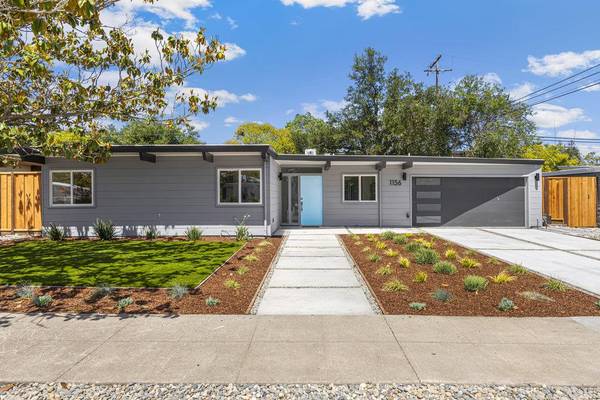
$2,300,000
Single Family Home
1156 Parkwood WAY, Redwood City, CA 94061
Completely remodeled & professionally designed Eichler showcase home spiritually inspired for the 21st Century. Inviting...
Listed by Boyenga Team of Compass

$5,050,000
Single Family Home
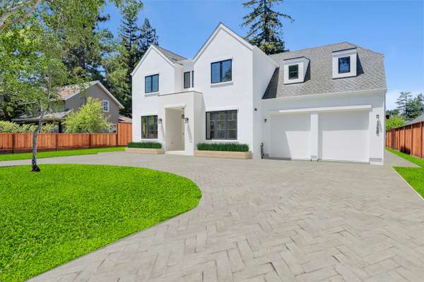
1200 Stockbridge AVE, Redwood City, CA 94061
Located on the highly coveted Stockbridge Ave on the Atherton Border, Cypress Capital Group brings you another stunning ...
Listed by Boyenga Team of Compass
MARKET TRENDS

listing detail
getting around
Getting around Redwood City
Caltrain
Redwood City station at 1 James Avenue, downtown, is a stop for local, limited and express trains, with 557 parking spaces in three lots and BikeLink lockers. SamTrans routes ECR, EPX, 270, 276, 278, 296 and 397 connect there. To the south, Atherton's station closed in December 2020, so the next stop is Menlo Park.
Freeways and arterials
US 101 runs along the bay side, with Redwood Shores on its far side; I-280 runs through the western hills. Woodside Road (SR 84) links the two and continues to the port as Seaport Boulevard, and El Camino Real (SR 82) runs north-south through the middle of town.
Bay Trail and Bair Island
The Bay Trail passes the port and, along Bair Island Road, leads to a bridge over Redwood Creek onto Inner Bair Island, where raised observation platforms look over more than 1,400 acres of restored marsh. In Redwood Shores the trail follows Belmont Slough past the Shores library branch.
By boat
The Port of Redwood City has the only public boat launch with access to San Francisco Bay south of Coyote Point, plus a public fishing pier, per the port.
living here
Living in Redwood City
Courthouse Square and downtown history
The 1910 county courthouse on Courthouse Square is the fourth built on that block since 1858 and is listed on the National Register; its Neo-Classical front was reconstructed in 2006. Nearby, the Diller-Chamberlain Store at 726 Main Street, built in 1859, is the county's oldest commercial building, per the city's Path of History markers. The San Mateo County History Museum is at 2200 Broadway.
Theater district
Downtown's movie palace opened as the New Sequoia in 1928 and reopened as the Fox Theater in 1950, and the 1904 Sequoia High School site on Broadway is now a cinema and retail complex, per the city's Path of History.
Port of Redwood City
Founded by city charter in 1937 on a channel used since 1851, the port calls itself the only deep-water port in the South San Francisco Bay, 18 nautical miles south of San Francisco. It handles bulk, neo-bulk and liquid cargo and has more than a mile of public waterfront walkways, a fishing pier and a boat launch at 675 Seaport Boulevard.
Parks and open space
The city's park map lists Stulsaft Park (about 42 acres) in the Farm Hill hills, Red Morton Community Park (about 28 acres) in Roosevelt, and Hoover Park (about 10 acres) on the east side. San Mateo County's Edgewood Park & Natural Preserve, 467 acres off Edgewood Road near I-280, is known for its serpentine grassland wildflowers each spring.
Libraries
The Main Library sits in the 1921 Redwood City Fire Station No. 1, remodeled to house the library in 1989. Branches include Schaberg (completed in 1957) and the 24,000 sq ft Redwood Shores branch on Belmont Slough (2008); the Fair Oaks branch on Middlefield Road moved to San Mateo County Libraries in 2021 as the North Fair Oaks Library.
Bair Island
Just across Highway 101 from downtown, Inner Bair Island is being returned to tidal marsh, more than 1,400 acres of it, with a Bay Trail bridge and viewing platforms. A 1982 referendum stopped a planned South Shores build-out there, per the library's local history.
your redwood city team
Buy or sell in Redwood City with the Boyenga Team
Eric and Janelle Boyenga and the Property Nerds® at Compass have sold more than 2,520 Silicon Valley homes, $2.6+ billion in all, since 1996. We know Redwood City block by block, from pricing and prep to the off-market homes most buyers never see.
Search Redwood City homes Get my home value (408) 373-1660 (650) 383-8606
how we help
Property Nerds® in Redwood City
Pricing from the data
We compare recent sales street by street, adjusting for lot, condition, schools and style, so you buy or list at a price the market will support.
Prep that pays
Selling? We focus prep money where Redwood City buyers notice it. Compass Concierge can start eligible work with nothing due upfront.
See homes first
Buying? Compass Private Exclusives and our network show you homes before they reach the public sites.
faq
Redwood City real estate FAQ
Is every Redwood City address inside the city?
No. Emerald Hills (Emerald Lake Hills), Palomar Park, North Fair Oaks, the Horgan Ranch blocks and small pockets such as Kensington Square and Oak Knoll carry Redwood City addresses but are unincorporated San Mateo County, with county planning and permits. Part of the Emerald Lake area is in the Town of Woodside, and only about 4% of ZIP 94062's land is inside the city.
Which school districts serve Redwood City?
The Redwood City School District for about 79% of the city's land and the Belmont-Redwood Shores School District for Redwood Shores (TK-8), with a sliver near the San Carlos line in the San Carlos School District, and the Sequoia Union High School District for high school everywhere. Check the exact address with each district.
Is Redwood Shores in a flood zone?
Redwood Shores relies on levees; the city raised more than 3 miles of them in 2010 to meet FEMA requirements. In April 2020 FEMA told the city that unless the levee system is modified to qualify for accreditation, the flood map will be revised to show coastal flood risk, which the regional flood agency says would bring about 4,700 households under a flood insurance requirement. Check the current FEMA map for the address.
Are there wildfire hazard zones in Redwood City?
On the western edge. The CAL FIRE map the city publishes (February 2025 recommended local zones) puts about a quarter of the Farm Hill association area in a High zone, and CAL FIRE's state-area map, adopted in April 2024, puts unincorporated Emerald Lake Hills in Moderate and High zones. Check the hazard disclosure for any hillside address.
Where does 'Climate Best by Government Test' come from?
A 1925 slogan contest. The library's local history says the Chamber of Commerce and the Real Estate Board each ran one, the winning line was later shortened to 'Climate Best By Government Test', and the claim leaned on government climate surveys begun before World War I.
More Property Nerd guides: San Carlos Belmont San Mateo Burlingame San Francisco Atherton Woodside Portola Valley Menlo Park Palo Alto Los Altos Hills Los Altos Mountain View Cupertino Sunnyvale Los Gatos Monte Sereno Saratoga Campbell Santa Clara San José neighborhoods Silicon Valley schools

Coming Soon
Commute Score
Coming Soon
Coming Soon
demographics
Population:
Density:
Households:
Gender
Coming Soon
Coming Soon
Coming Soon
Coming Soon
more redwood city neighborhood guides
Neighborhood guides in Redwood City
See every guide in the Nerd Portal.

Eric & Janelle Boyenga
homes@boyenga.com