

belmont · san mateo county
Belmont Real Estate & Neighborhood Guide
Belmont covers about 4.6 square miles of the mid-Peninsula between San Mateo and San Carlos. It runs from Island Park on the bay side of US 101, across the flats along Old County Road, the Caltrain line and El Camino Real, and up into hills that reach toward State Route 92. The city incorporated on October 29, 1926, and Ralston Hall is on both the National Register (as the William C. Ralston House) and the state landmark list (No. 856). The town filled in after World War II: county assessor records date about 70 percent of its roughly 6,700 single-family houses to 1940 through 1969. The 2020 census counted 11,169 housing units, so condominiums, townhouses and apartments make up much of the rest.
population, 2020 census
land area
zip codes
incorporated
3918 Christian Drive, Belmont, CA 94002
Single Family Home 5 Beds 4 Baths 2,549 SqFt
Listed by Boyenga Team of Boyenga Team / Compass3106 Marburger AVE, Belmont, CA 94002
Single Family Home 3 Beds 2 Baths 1,340 SqFt
Listed by Steven C Gerry of Compass Commercial
2103 Pullman AVE, Belmont, CA 94002
Single Family Home 3 Beds 3 Baths 2,530 SqFt
Listed by Michael D Neri of Elevation Real Estate400 Davey Glen Rd 4824, Belmont, CA 94002
Condo 1 Bed 1 Bath 725 SqFt
Listed by Adam Modzeleski of Weichert, REALTORS Rainbow
2911 Alhambra DR, Belmont, CA 94002
Vacant Land 0.14 Acres
Listed by Calvin Li of Excel Realty2913 Alhambra DR, Belmont, CA 94002
Vacant Land 0.14 Acres
Listed by Calvin Li of Excel Realty2915 Alhambra DR, Belmont, CA 94002
Vacant Land 0.2 Acres
Listed by Calvin Li of Excel Realty2917 Alhambra DR, Belmont, CA 94002
Vacant Land 0.14 Acres
Listed by Calvin Li of Excel RealtyBelmont, CA 94002
Vacant Land 100.57 Acres
Listed by Cameron Jeffs of Coldwell Banker Realty
3900 Marsten AVE, Belmont, CA 94002
Vacant Land 19.75 Acres
Listed by Wong Real Estate Grp of KW Advisors1315 Alameda De Las Pulgas, Belmont, CA 94002
Vacant Land 0.56 Acres
Listed by Ravi Jagtiani of Intero Real Estate Services0 Belmont Ave, Belmont, CA 94002
Vacant Land 0.72 Acres
Listed by Lily Yang of Vista Investment & Realty15 Waterloo CT, Belmont, CA 94002
Single Family Home 5 Beds 3 Baths 2,750 SqFt
Listed by Debbie Wilhelm of Coldwell Banker Realty1618 Fairway DR, Belmont, CA 94002
Single Family Home 5 Beds 3 Baths 3,173 SqFt
Listed by Sanit Bordeianu of Coldwell Banker Realty2728 Wakefield DR, Belmont, CA 94002
Single Family Home 4 Beds 3.5 Baths 2,850 SqFt
Listed by Kateryna Davydova of Compass2725 Belmont Canyon RD, Belmont, CA 94002
Single Family Home 4 Beds 3.5 Baths 2,720 SqFt
Listed by Holly Noto of Coldwell Banker Realty1811 Robin Whipple WAY, Belmont, CA 94002
Single Family Home 4 Beds 3 Baths 2,077 SqFt
Listed by Vicky Yu of Coldwell Banker Realty1239 Talbryn DR, Belmont, CA 94002
Single Family Home 4 Beds 3.5 Baths 2,551 SqFt
Listed by Jim Enes of Sequoia Real Estate2304 Casa Bona AVE, Belmont, CA 94002
Single Family Home 4 Beds 3 Baths 2,895 SqFt
Listed by Jenn Gilson of Golden Gate Sotheby's International Realty1000 O Neill ST, Belmont, CA 94002
Multi-Family 6 Beds 4 Baths 3,023 SqFt
Listed by Abe Matar of Landmark Real Estate Services
CA Belmont
Belmont
Listings
- 1/26 26
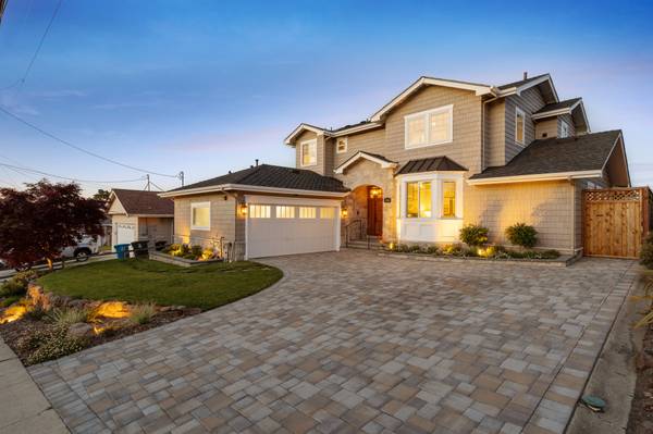 5 Beds 4 Baths 2,549 SqFt$2,738,000Active
 - 1/52 52
 3 Beds 2 Baths 1,340 SqFt$1,999,999Price Dropped by $199K
3106 Marburger AVE, Belmont, CA 94002
Listed by Steven C Gerry of Compass Commercial
Single Family Home
- 1/26 26
 1 Bed 1 Bath 725 SqFt$535,000Active
400 Davey Glen Rd 4824, Belmont, CA 94002
Listed by Adam Modzeleski of Weichert, REALTORS Rainbow
Condo
neighborhoods
Belmont neighborhoods
The city's own neighborhood map divides Belmont into 14 areas, and these guides group the residential ones into nine. East of the rail line, Sterling Downs & Homeview are flat late-1940s and early-1950s tracts on 5,000 sq ft lots, and Island Park, across US 101, has about 122 homes from 1990 and 1997 in FEMA flood Zone AE. Downtown Belmont mixes 1920s and 1930s cottages with the El Camino Real village core, while McDougal (the 1950s Carlmont tracts) and Central Belmont cover the slopes on either side of Ralston Avenue. Westward the ground climbs and the houses get newer: Cipriani, Plateau-Skymont, Belmont Heights and Western Hills & Carlmont run from 1950s ranch streets to 1970s and later planned developments, with hillside zoning districts and CAL FIRE's Moderate fire hazard mapping in parts of the western hills. One pocket is not Belmont at all: the Harbor Industrial Area along Harbor Boulevard and Old County Road is unincorporated San Mateo County.
Central Belmont
The hills north of Ralston Avenue between the Alameda and Old County Road: 1920s country-club lots, postwar streets, condos near El Camino Real and the Belmont Caltrain station.
Cipriani
Northwest Belmont's hillside streets between the Alameda and San Juan Boulevard: mostly 1950s and 1960s houses on 6,000-square-foot zoning, around Cipriani Elementary and Cipriani Park, up to the San Mateo line.
Plateau-Skymont
Belmont's northwest hills above Ralston Avenue, west of San Juan Boulevard: early-1960s houses on Skymont Drive, Adelaide Way and Plateau Drive, steep hillside lots and open space, with Highway 92 next door.
Belmont Heights
Belmont's southwest hills south of Ralston Avenue: late-1950s streets off Tahoe Drive, 1960s and 1970s houses along Hallmark Drive, Fox Elementary, and the Waterdog Lake open space next door.
Western Hills & Carlmont
South of Ralston Avenue between Davis Drive and the Alameda: Carlmont High, Ralston Middle and the library, condos and apartments near the Alameda, 1970s-1990s hillside houses, and Waterdog Lake's open space.
McDougal
About 155 acres of 1950s Carlmont-tract houses south of Ralston Avenue, between Alameda de las Pulgas and Twin Pines Park, with McDougal Park in the middle and Carlmont Village on the corner.
Downtown Belmont
The blocks south of Ralston Avenue from Twin Pines Park to Old County Road: 1920s to 1950s houses on Sixth and Sunnyslope, hillside lots on Vine and Talbryn, City Hall, and the El Camino Real village core.
Sterling Downs & Homeview
Belmont's flat northeast corner between Old County Road and US 101: Homeview's late-1940s houses south of Ralston Avenue, Sterling Downs' early-1950s tract north of it, and the Caltrain station a short walk west.
Island Park
Belmont's only neighborhood east of US 101: about 122 homes from 1990 and 1997 on private lanes off Island Parkway, beside the Belmont Sports Complex and the slough trails, in FEMA flood Zone AE.
schools
Belmont public schools
Elementary and middle
- Belmont-Redwood Shores School District. Census maps place every Belmont parcel in this district, which also serves Redwood City's Redwood Shores. Its schools in Belmont are Central Elementary (525 Middle Road), Cipriani Elementary (2525 Buena Vista Avenue), Fox Elementary (3100 Saint James Road), Nesbit School (500 Biddulph Way) and Ralston Middle School (2675 Ralston Avenue). Redwood Shores Elementary (225 Shearwater Parkway) and Sandpiper School (801 Redwood Shores Parkway) are on the Redwood Shores side. The district office is at 1075 Old County Road.
High school
- Sequoia Union High School District. Census maps place all of Belmont in Sequoia Union. Carlmont High School is in Belmont at 1400 Alameda de las Pulgas; the district assigns its high schools by address through an online boundary search.
property nerd note
Every Belmont parcel falls in the same two districts on Census maps, so the real question is the school. Look up the exact address in the Belmont-Redwood Shores School District's enrollment boundary map and Sequoia Union's boundary search, and confirm with each district before you write an offer, because attendance boundaries change. Start with our Silicon Valley schools guide.
zip codes
Belmont ZIP codes
Belmont's only ZIP code; Census ZIP areas put about 99.9 percent of the city in it. About 82 percent of 94002's land is inside the city and about 17 percent is unincorporated, mostly unaddressed open land in the hills to the west, plus the Harbor Industrial Area. County records list 53 unincorporated parcels with Belmont addresses, all in the Harbor Industrial Area on Harbor Boulevard, Industrial Road, Old County Road, O'Neill Avenue and Elmer Street, mostly light industrial and warehouse lots plus mobile home park parcels on Harbor Boulevard. Those are under county planning and permits.
RECENTLY SOLD LISTINGS

$3,000,000
Single Family Home
3402 Hillcrest DR, Belmont, CA 94002
A rare find in Belmont, set on an exceptional 13,038sf nearly level lot with bay views, this 1,865sf home offers a disti...
Listed by Laura Bertolacci of Christie's International Real Estate Sereno

$3,430,000
Single Family Home
2808 Wakefield DR, Belmont, CA 94002
Life in Belmonts Hallmark neighborhood begins with the outdoors just beyond your door. Waterdog Lake and Open Space rest...
Listed by Rena Provencio of A. Meadows Real Estate

$2,300,000
Single Family Home
316 Hiller ST, Belmont, CA 94002
Elegantly appointed and thoughtfully designed, this exceptional single-level residence offers a rare blend of refined st...
Listed by Greg Celotti of Compass
MARKET TRENDS
listing detail
getting around
Getting around Belmont
Caltrain
Belmont station is at 995 El Camino Real, just north of Ralston Avenue, in fare zone 2, with 375 parking spaces, 18 bike racks and on-demand bike lockers. The neighboring stops are San Carlos, about 1.4 miles south, and Hillsdale, about 2 miles north (straight-line).
Buses
SamTrans route ECR runs the length of El Camino Real between Daly City BART and the Palo Alto Transit Center. Route 260 links San Carlos Caltrain with Carlmont Village at Ralston Avenue and Alameda de las Pulgas, and route 397 (San Francisco to Palo Alto) also stops at the Belmont station.
Freeways
Ralston Avenue is the cross-town spine. Its east end meets US 101 at the Ralston Avenue interchange beside Island Park, and its west end meets State Route 92, which connects to I-280. El Camino Real is State Route 82.
Bikes and trails
The city's trail data maps bike routes on Ralston Avenue, Old County Road and Island Parkway, a paved Belmont Slough Trail and Belmont Creek Trail east of US 101, and a bike bridge from Island Park to Oracle Parkway in Redwood Shores.
living here
Living in Belmont
Twin Pines Park and the civic center
Twin Pines Park sits on a public parcel of about 17 acres south of Ralston Avenue in Downtown Belmont, with Belmont Creek running through it. City Hall (One Twin Pines Lane), the police department and the Twin Pines Senior and Community Center are at its east end.
Water Dog Lake and the open space trails
In the southwestern hills, the city's trail data maps about 3.5 miles of trail in Water Dog Lake Park and about 6.5 miles in the John Brooks and Water Dog Lake Open Space Area, including the Lake Road, Chaparral, Rambler and John Brooks trails.
Belmont Sports Complex and the slough
East of US 101 at 550 Island Parkway, the Sports Complex has ball fields, a playground and a conference center building, and the paved Belmont Slough Trail follows the water around Island Park.
Belmont Library
The San Mateo County Libraries branch is at 1110 Alameda de las Pulgas, across the Alameda from the Carlmont Village shopping center.
Shopping streets
Shops and restaurants cluster at the El Camino Real and Ralston Avenue crossroads, along Ralston Avenue east of Old County Road, and at Carlmont Village on the corner of Ralston Avenue and Alameda de las Pulgas.
your belmont team
Buy or sell in Belmont with the Boyenga Team
Eric and Janelle Boyenga and the Property Nerds® at Compass have sold more than 2,520 Silicon Valley homes, $2.6+ billion in all, since 1996. We know Belmont block by block, from pricing and prep to the off-market homes most buyers never see.
Search Belmont homes Get my home value (408) 373-1660 (650) 383-8606
how we help
Property Nerds® in Belmont
Pricing from the data
We compare recent sales street by street, adjusting for lot, condition, schools and style, so you buy or list at a price the market will support.
Prep that pays
Selling? We focus prep money where Belmont buyers notice it. Compass Concierge can start eligible work with nothing due upfront.
See homes first
Buying? Compass Private Exclusives and our network show you homes before they reach the public sites.
faq
Belmont real estate FAQ
What ZIP code is Belmont?
94002. Nearly all of the city is in it, but about 17 percent of the ZIP's land is unincorporated county land, including the Harbor Industrial Area along Harbor Boulevard and Old County Road. Check the city on the tax bill for any address in that area.
Which school districts serve Belmont?
Census maps put the whole city in the Belmont-Redwood Shores School District for elementary and middle school and the Sequoia Union High School District for high school. Confirm the school for an exact address with each district, because attendance boundaries change.
Is any of Belmont in a flood zone?
Island Park, east of US 101, is mostly in FEMA Zone AE, and in 2026 the city began studying whether it can join the Redwood Shores sea level rise protection project. Elsewhere, narrow Zone A strips follow Belmont Creek, and Homeview and the flats near El Camino Real are in shaded Zone X. Check the FEMA map for each parcel.
Are there hillside or fire rules?
Belmont's zoning map includes three Hillside Residential and Open Space districts (HRO1, HRO2 and HRO3) in the western hills, and CAL FIRE's 2025 map puts parts of Belmont Heights, Plateau-Skymont, Cipriani and Western Hills in a Moderate fire hazard severity zone. The city's slope map also flags areas steeper than 30 percent. Ask the city what geotechnical and design review applies before planning work on a hillside lot.
What are Belmont's lot-size rules?
The single-family zones set minimum lot area per home: R1C 5,000 sq ft, R1B 6,000 sq ft, R1A 9,600 sq ft, R1H half an acre and R1E one acre (city zoning map). Around the station and El Camino Real, the Belmont Village Specific Plan districts allow mixed use and higher density.
More Property Nerd guides: Redwood City San Carlos San Mateo Burlingame San Francisco Atherton Woodside Portola Valley Menlo Park Palo Alto Los Altos Hills Los Altos Mountain View Cupertino Sunnyvale Los Gatos Monte Sereno Saratoga Campbell Santa Clara San José neighborhoods Silicon Valley schools

Coming Soon
Commute Score
Coming Soon
Coming Soon
demographics
Population:
Density:
Households:
Gender
Coming Soon
Coming Soon
Coming Soon
Coming Soon

Eric & Janelle Boyenga
homes@boyenga.com