

campbell · santa clara county
Campbell Real Estate & Neighborhood Guide
Campbell covers about 6 square miles of the southwest Santa Clara Valley, between San José, Los Gatos and Saratoga. Benjamin Campbell bought 160 acres here in 1851; the first town subdivision was recorded in 1887 beside the railroad, and the town grew as a fruit-shipping point, with a 17-acre cooperative drying yard by 1892 and canneries such as J.C. Ainsley, Hyde and Payne. Campbell incorporated in 1952, when the city covered under a square mile, and annexed outward as orchards turned into tracts: about two-thirds of today's single-family homes were built from 1950 to 1979, per county assessor data. The 2020 census counted 18,385 housing units, from ranch-house streets to condos, duplexes and apartments.
population, 2020 census
land area
zip codes
incorporated
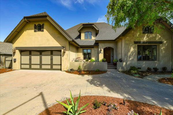
236 North Central Avenue, Campbell, CA 95008
Single Family Home 6 Beds 5 Baths 4,180 SqFt
Listed by Boyenga Team of Boyenga Team / Compass800 Monica Ln, Campbell, CA 95008
Single Family Home 3 Beds 2 Baths 1,732 SqFt
Listed by Boyenga Team of Boyenga Team / Compass601 N Central Ave, Campbell, CA 95008
Single Family Home 4 Beds 3 Baths 1,979 SqFt
Listed by Boyenga Team of Boyenga Team / Compass911 Monica Ln, Campbell, CA 95008
Single Family Home 4 Beds 3 Baths 2,046 SqFt
Listed by Boyenga Team of Boyenga Team / Compass219 Shelley Avenue, Campbell, CA 95008
Single Family Home 3 Beds 2.5 Baths 2,002 SqFt
Listed by Boyenga Team of Boyenga Team / Compass708 Birch Dr, Campbell, CA 95008
Condo 2 Beds 992 SqFt
Listed by Eric & Janelle Boyenga of Boyenga Team / Compass1509 Walnut DR, Campbell, CA 95008
Single Family Home 3 Beds 3 Baths 3,630 SqFt
Listed by Seb Frey of Compass
204 N 3rd ST, Campbell, CA 95008
Single Family Home 4 Beds 3 Baths 2,381 SqFt
Listed by Robert Gosalvez of Compass2255 Wren WAY, Campbell, CA 95008
Single Family Home 4 Beds 2 Baths 1,486 SqFt
Listed by George Montanari of Compass1500 W San Tomas Aquino RD, Campbell, CA 95008
Single Family Home 4 Beds 2 Baths 2,078 SqFt
Listed by JOHN MARTINDALE of GS STRATEGIES, INC.
574 Harrison AVE, Campbell, CA 95008
Single Family Home 4 Beds 4 Baths 2,017 SqFt
Listed by Omar Khayat of Olive Realty
786 Sharmon Palms LN, Campbell, CA 95008
Multi-Family 8,064 Sqft Lot
Listed by Ramaswamy Ramkumar of Sabari Realty185 Union Ave 14, Campbell, CA 95008
Condo 1 Bed 1 Bath 704 SqFt
Listed by Robert Song of Compass903 Dry Creek RD, Campbell, CA 95008
Single Family Home 6 Beds 5.5 Baths 4,981 SqFt
Listed by Sarah Hoang of Compass154 Virginia AVE, Campbell, CA 95008
Single Family Home 5 Beds 5.5 Baths 4,427 SqFt
Listed by Kevin Lam of Anne Reyes, Broker1487 W Hacienda AVE, Campbell, CA 95008
Single Family Home 5 Beds 5.5 Baths 4,391 SqFt
Listed by Axis Elite Team of Aspire Homes1521 Capri DR, Campbell, CA 95008
Single Family Home 5 Beds 5.5 Baths 4,156 SqFt
Listed by Frances Ibay of Thomas James Real Estate Services, Inc,432 Virginia AVE, Campbell, CA 95008
Single Family Home 5 Beds 3.5 Baths 3,337 SqFt
Listed by Ismar Maslic of Montalvo Realty1371 Juanita WAY, Campbell, CA 95008
Single Family Home 4 Beds 4 Baths 3,498 SqFt
Listed by Axis Elite Team of Aspire Homes28 Hunt WAY, Campbell, CA 95008
Single Family Home 5 Beds 5 Baths 3,596 SqFt
Listed by Kelly Lawson of Lawson Realty
CA Campbell
Campbell
Campbell Real Estate & Homes for Sale
Living in Campbell
Campbell is a city of about 44,000 people (2020 census) on roughly 6 square miles between San José, Los Gatos and Saratoga. It began as a fruit-shipping town beside the railroad, incorporated in 1952 and grew outward as orchards became tracts. The old main street on E. Campbell Avenue is now downtown, with VTA light rail running beside it.
Campbell Neighborhoods
Neighborhoods include Downtown Campbell, the streets around the Campbell Community Center, Morgan Park, Hazelwood, San Tomas and Hacienda in the San Tomas Area, San Tomas West, White Oaks, Campbell Village, Apricot Avenue and Pruneyard–Dry Creek. Most homes are 1950s–70s ranch houses, with condos and townhomes near the Pruneyard and downtown.
Schools
Campbell is split among three elementary districts: Campbell Union for most of the city, Moreland in the northwest and Cambrian on the east side. All of Campbell is in the Campbell Union High School District. Confirm boundaries for a specific home before you buy.
Downtown & Lifestyle
E. Campbell Avenue has restaurants, shops and a Sunday farmers market, and the Pruneyard sits just east of Highway 17. The Los Gatos Creek Trail runs through town past Campbell Park and Los Gatos Creek County Park.
Commute
VTA’s Green Line stops at Winchester, Downtown Campbell and Hamilton stations. Highway 17 runs through the east side, Highway 85 along the south edge, and San Tomas Expressway heads north into Santa Clara.
Buying or Selling in Campbell
From San Tomas Area lots to Pruneyard-area condos, the Boyenga Team / Compass works across Campbell. Call Eric & Janelle Boyenga at (408) 373-1660 or (650) 383-8606, or send us a message below.
Listings
neighborhoods
Campbell neighborhoods
Campbell's neighborhoods follow its annexation map. The 1952 city held less than a square mile around downtown and the railroad; the city's annexation layer shows most of the rest added piece by piece in the 1950s, 1960s and 1970s, which is why tract streets from different decades sit side by side. Older houses cluster near downtown and the Community Center. Ranch-house tracts fill the north, east and west. In the southwest, the San Tomas Area keeps larger, irregular lots and some streets without curbs under Campbell's first neighborhood plan (1993), and the east side has its own Campbell Village Neighborhood Plan. The edges are ragged: San José wraps the city, some homes with Campbell 95008 addresses are in San José, and a few Campbell streets carry Los Gatos or San José mailing addresses.
Downtown Campbell
Campbell's original 1880s town site by the old railroad: an E. Campbell Ave main street, a light-rail stop, and blocks of Victorian cottages, bungalows, condos and new townhomes.
Campbell Community Center
The streets between Hamilton Ave and W. Campbell Ave west of Winchester Blvd, built around the 1930s Campbell High School campus that is now the city's community center, pool and theater.
Morgan Park
The wedge between W. Campbell Ave, Winchester Blvd and San Tomas Expressway: postwar houses, 1960s fourplexes and 1970s-80s townhouses around John D. Morgan Park, one of Campbell's largest parks.
San Tomas West
Northwest Campbell between W. Campbell Avenue and Hamilton Avenue, west of San Tomas Expressway: 1950s-70s ranch-house tracts in the Moreland School District, with San José on three sides.
Hazelwood
Ranch-house blocks around Hazelwood Avenue in Campbell's San Tomas Area, between San Tomas Aquino Road and Virginia Avenue, where some streets are meant to stay without curbs or sidewalks.
San Tomas
The west side of Campbell's San Tomas Area, from San Tomas Aquino Road to Westmont High: deep, irregular lots, 1960s tracts, new courts, and streets the city plans to keep rural.
Hacienda
Southwest Campbell along W. Hacienda Ave, inside the San Tomas Area plan: 1940s-60s tracts on larger lots, streets without standard sidewalks, Jack Fischer Park and two Campbell Union schools.
White Oaks
Campbell's southern wedge between Highway 17 and S. Bascom Avenue: 1955 tract streets, 1980s townhome communities and new infill along White Oaks Road, with a footbridge to Los Gatos Creek County Park.
Campbell Village
The former Cambrian No. 36 county pocket and the Central Park streets east of Highway 17, annexed in 2013: about 485 parcels of mostly 1940s-60s homes, many on streets without curbs or sidewalks, under their own plan.
Apricot Avenue
The condo and townhome district between Highway 17 and S. Bascom Avenue, across E. Campbell Avenue from the Pruneyard: late-1970s and 1980s complexes on Union and Apricot avenues, plus a park on a former orchard lot.
Pruneyard–Dry Creek
The Pruneyard's shops, offices and newer apartments, plus about 950 mostly one-story 1940s-60s houses east of S. Bascom Avenue, from Hamilton Avenue to the Dry Creek Road backyards. Dry Creek Road is mostly San José.
schools
Campbell public schools
Elementary and middle
- Campbell Union School District. Serves most of Campbell on U.S. Census maps, including downtown, the Community Center area and the San Tomas Area. Its campuses in or at the edge of the city include Capri, Rosemary, Forest Hill and Village elementary schools, Campbell School of Innovation (pre-K through 8) and Rolling Hills Middle.
- Moreland School District. Serves northwest Campbell, north of W. Campbell Avenue and west of San Tomas Expressway, plus the Campbell blocks just west of San Tomas Aquino Road, on U.S. Census maps. Payne and Latimer elementary schools and Moreland Middle sit just over the line in San José.
- Cambrian School District. Serves the east side on city parcel records and U.S. Census maps: White Oaks, Campbell Village, the Apricot Avenue area and most streets east of S. Bascom Avenue south of E. Campbell Avenue. Check any address east of Highway 17.
High school
- Campbell Union High School District. Serves all of Campbell. The district runs Branham, Del Mar, Leigh, Prospect, Westmont and Boynton high schools; Westmont High, on Westmont Avenue at the city's southwest edge, is the campus closest to the San Tomas Area. The district's first school, Campbell High School, closed in 1980 and is now the Campbell Community Center.
property nerd note
In Campbell the elementary district does not follow the city line or neighborhood names: Campbell Union, Moreland and Cambrian all serve Campbell addresses, and a school across the street may belong to a different district. Look up the parcel's district first (U.S. Census school-district maps are a quick check), then confirm the assigned school with the district itself. Boundaries change, so confirm before you write an offer. Start with our Silicon Valley schools guide.
zip codes
Campbell ZIP codes
Nearly all City of Campbell addresses: about 21,150 of the roughly 22,100 address points in the city's address layer. The ZIP also reaches into San José, so a 95008 address is not proof of Campbell city limits. For example, the blocks north of San Tomas Aquino Creek around San Tomas Park (Valerie Dr, Lemoyne Way, Montezuma Dr, Maximilian Dr and the Via streets) are in San José with 95008 addresses, per Census maps. Check the parcel's jurisdiction near any city line.
About 320 City of Campbell addresses use Los Gatos 95032 mailing addresses, mostly in the far southwest south of Highway 85 near Rolling Hills Middle (Elwood Dr, Hyde Dr, Bearden Dr and nearby courts) and some near S. Bascom Avenue, per the city's address layer.
Small groups of City of Campbell addresses near the north and east edges use San José mailing addresses: 95128 (for example Ravenscourt Ave and Monica Ln), 95125 (Grace Ave, Phantom Ave) and 95117 (Millich Dr, Valley Forge Way), per the city's address layer.
RECENTLY SOLD LISTINGS

$1,725,000
Multi-Family
1481-1483 Sheffield AVE, Campbell, CA 95008
Surrounded by single family homes, this first time on the market duplex has the land and location that is hard to find. ...
Listed by Brett Mattos of Brett Mattos, Broker

$1,725,000
Multi-Family
1481-1483 Sheffield AVE, Campbell, CA 95008
Surrounded by single family homes, this first time on the market duplex has the land and location that is hard to find. ...
Listed by Brett Mattos of Brett Mattos, Broker

$1,311,110
Townhouse
503 Latimer CIR, Campbell, CA 95008
Discover this rarely available, beautifully updated 4-bedroom, 2.5-bath townhouse near the heart of Campbell in the desi...
Listed by Boyenga Team of Compass
MARKET TRENDS

listing detail
getting around
Getting around Campbell
Light rail
VTA's Green Line has three Campbell stations: Winchester (the south end of the line, on S. Winchester Blvd), Downtown Campbell (Railway Ave) and Hamilton (Creekside Way). From Campbell the line runs northeast to Diridon station and downtown San José, then on to Old Ironsides in Santa Clara. The Campbell stations opened October 1, 2005, and the city's transit map shows planned stops beyond Winchester toward Los Gatos.
Freeways and expressway
Highway 17 runs north-south through east Campbell, with ramps at Hamilton Avenue and at Camden Avenue/San Tomas Expressway. Highway 85 runs along the south edge; it has only a partial interchange at Winchester Boulevard, so many drivers use Bascom Avenue or Saratoga Avenue. San Tomas Expressway starts at Highway 17 and Winchester Boulevard and runs north into Santa Clara.
Buses
VTA Route 26 crosses the city on Campbell Avenue between West Valley College and Eastridge, Route 37 uses Pollard Road and Hacienda Avenue on its way to Winchester station and Capitol Station, and the city's transit-stop data shows Route 60 on Winchester Boulevard and Route 61 on Bascom Avenue.
Trail
The Los Gatos Creek Trail's 9.7-mile main segment runs from Lexington Reservoir through Campbell to Meridian Avenue in San José. In Campbell it passes Los Gatos Creek County Park and Campbell Park, about three blocks from downtown, with paths on both banks between San Tomas Expressway and Campbell Park.
living here
Living in Campbell
Downtown and the farmers market
E. Campbell Avenue is the historic main street, near where the avenue crosses the old railroad, now the light-rail line. The farmers market runs Sundays 9 am to 1 pm year-round on E. Campbell Ave between Central Avenue and Third Street. Nearby, the 1928 water tower once held 75,000 gallons and now gets colored lights for holidays.
The Pruneyard
An open-air center of about 250,000 square feet at Campbell and Bascom avenues, just east of Highway 17, with shops, a hotel, a movie theater and office towers. Its name is on Pruneyard Shopping Center v. Robins, the 1980 U.S. Supreme Court free-speech case.
Los Gatos Creek Trail and County Park
Los Gatos Creek County Park, by Highway 17 and San Tomas Expressway, has fishing, a casting pond, a dog park and trails around large percolation ponds on the creek trail.
Campbell Community Center
The former Campbell High School campus at Winchester Boulevard and W. Campbell Avenue, about 29 acres in city GIS. The city bought it in 1985, five years after the school closed; the old auditorium reopened as the Heritage Theater in 2004, and the campus holds classes, athletic fields and event rentals.
Historical museum
The Campbell Historical Museum (51 N. Central Ave) and the Ainsley House (300 Grant St) are downtown, per city GIS. The Ainsley House is a 1925 English Tudor-style house built for canning pioneer J.C. Ainsley and moved in the early 1990s from Hamilton and Bascom avenues.
Parks
John D. Morgan Park (about 18 acres in city GIS), Campbell Park on the creek trail (about 12), Jack Fischer Park (about 4), Edith Morley Park (about 4, with a community garden), Stojanovich Family Park and downtown's Orchard City Green.
your campbell team
Buy or sell in Campbell with the Boyenga Team
Eric and Janelle Boyenga and the Property Nerds® at Compass have sold more than 2,520 Silicon Valley homes, $2.6+ billion in all, since 1996. We know Campbell block by block, from pricing and prep to the off-market homes most buyers never see.
Search Campbell homes Get my home value (408) 373-1660 (650) 383-8606
how we help
Property Nerds® in Campbell
Pricing from the data
We compare recent sales street by street, adjusting for lot, condition, schools and style, so you buy or list at a price the market will support.
Prep that pays
Selling? We focus prep money where Campbell buyers notice it. Compass Concierge can start eligible work with nothing due upfront.
See homes first
Buying? Compass Private Exclusives and our network show you homes before they reach the public sites.
faq
Campbell real estate FAQ
What ZIP code is Campbell?
Almost all City of Campbell addresses are 95008. A few Campbell streets use Los Gatos 95032 or San José 95117, 95125 or 95128 mailing addresses, and some San José homes near the city line have Campbell 95008 addresses.
Does a Campbell address mean the home is in the City of Campbell?
Not always. Pockets just outside the city, such as the blocks around San Tomas Park north of San Tomas Aquino Creek, are in San José but use Campbell 95008 addresses. Jurisdiction decides permits, zoning and some services, so check the parcel record.
Which school districts serve Campbell?
Three elementary districts (Campbell Union for most of the city, Moreland in the northwest, Cambrian on the east side) and one high school district, Campbell Union High. Check the exact address with the district; boundaries change.
What is the San Tomas Area?
About 1.5 square miles of southwest Campbell covered by the San Tomas Area Neighborhood Plan, adopted in 1993 and amended in 2000, 2019 and 2022. It keeps the area low-density, caps house size at 0.45 FAR, sets larger setbacks and keeps some streets without curbs, gutters and sidewalks.
Is Campbell on light rail?
Yes. VTA's Green Line stops at Winchester, Downtown Campbell and Hamilton stations and runs to downtown San José and Santa Clara.
More Property Nerd guides: Palo Alto Los Altos Redwood City Menlo Park Mountain View Cupertino Sunnyvale Los Gatos Santa Clara Saratoga San Carlos Belmont San Mateo Burlingame San Francisco Atherton Los Altos Hills Monte Sereno Woodside Portola Valley San José neighborhoods Silicon Valley schools

Coming Soon
Commute Score
Coming Soon
Coming Soon
demographics
Population:
Density:
Households:
Gender
Coming Soon
Coming Soon
Coming Soon
Coming Soon

Eric & Janelle Boyenga
homes@boyenga.com