

saratoga · santa clara county
Saratoga Real Estate & Neighborhood Guide
Saratoga covers 12.8 square miles on the west edge of the Santa Clara Valley, where the flat valley floor meets the foothills of the Santa Cruz Mountains. It began with William Campbell's sawmill on what is now Saratoga Creek in 1848, took its name in 1865 from a mineral spring like the one at Saratoga Springs, New York, and then spent decades in orchards and vineyards. Residents voted to incorporate in 1956 to head off annexation by San Jose, and the city filled in as single-family neighborhoods from the 1950s through the 1970s. In 2020, about 84 percent of its homes were detached single-family houses; townhomes, condominiums and small apartment buildings make up the rest.
population, 2020 census
land area
zip codes
incorporated
15400 Madrone Hill RD, Saratoga, CA 95070
Vacant Land 12.46 Acres
Listed by Michael Kenyon of Compass
20388 Hill AVE, Saratoga, CA 95070
Single Family Home 9 Beds 10 Baths 7,495 SqFt
Listed by David Welton of CompassMinocqua CT, Saratoga, CA 95070
Single Family Home 4 Beds 3 Baths 3,300 SqFt
Listed by Dana & Cyndi of Compass21100 Saratoga Hills RD, Saratoga, CA 95070
Single Family Home 4 Beds 4 Baths 4,396 SqFt
Listed by Nevis and Ardizzone of Compass15217 Sobey RD, Saratoga, CA 95070
Single Family Home 4 Beds 3.5 Baths 4,700 SqFt
Listed by Nevis and Ardizzone of Compass14330 Paul AVE, Saratoga, CA 95070
Single Family Home 3 Beds 3 Baths 2,635 SqFt
Listed by Brenda Miller of Compass14434 Oak ST, Saratoga, CA 95070
Single Family Home 3 Beds 2 Baths 1,702 SqFt
Listed by Moe Baniani of Compass20720 4Th St 3, Saratoga, CA 95070
Condo 2 Beds 1 Bath 876 SqFt
Listed by Adam Modzeleski of Weichert, REALTORS Rainbow
15345 Bohlman RD, Saratoga, CA 95070
Single Family Home 5 Beds 6.5 Baths 5,500 SqFt
Listed by Frank Liu of Alliance Bay Realty0 Mt Eden RD, Saratoga, CA 95070
Vacant Land 28.29 Acres
Listed by Jeff Wyatt of Wyatt & Associates18540 Quito Grove CT, Saratoga, CA 95070
Single Family Home 5 Beds 5.5 Baths 5,212 SqFt
Listed by Robin Sedgwick of Coldwell Banker Realty21449 Toll Gate RD, Saratoga, CA 95070
Single Family Home 7 Beds 7.5 Baths 7,100 SqFt
Listed by Andy Tse of Intero Real Estate Services15863 Mina WAY, Saratoga, CA 95070
Single Family Home 5 Beds 5.5 Baths 5,472 SqFt
Listed by Jinaye Conley of Keller Williams Realty-Silicon Valley14950 Gypsy Hill RD, Saratoga, CA 95070
Single Family Home 4 Beds 4.5 Baths 5,008 SqFt
Listed by Andy Tse of Intero Real Estate Services14211 Juniper LN, Saratoga, CA 95070
Single Family Home 5 Beds 4.5 Baths 3,989 SqFt
Listed by Frances Ibay of Thomas James Real Estate Services, Inc,14744 Montalvo RD, Saratoga, CA 95070
Single Family Home 4 Beds 3 Baths 3,856 SqFt
Listed by Chuck Nunnally of KW Bay Area Estates14750 Sobey RD, Saratoga, CA 95070
Single Family Home 5 Beds 4.5 Baths 4,864 SqFt
Listed by Andy Tse of Intero Real Estate Services18625 SAGE CT, Saratoga, CA 95070
Single Family Home 5 Beds 4.5 Baths 3,929 SqFt
Listed by Steve McCarrick of Coldwell Banker Realty14275 Hilltop WAY, Saratoga, CA 95070
Single Family Home 5 Beds 3.5 Baths 3,571 SqFt
Listed by Andy Tse of Intero Real Estate Services20234 Edinburgh DR, Saratoga, CA 95070
Single Family Home 6 Beds 4 Baths 3,393 SqFt
Listed by Matt Cossell of KW Bay Area Estates
CA Saratoga
Saratoga
Saratoga Real Estate & Homes for Sale
Living in Saratoga
Saratoga is a city of about 31,000 people (2020 census) on about 12.8 square miles where the Santa Clara Valley floor meets the foothills of the Santa Cruz Mountains. It grew from a sawmill settlement and orchard town, incorporated in 1956, and filled in with single-family neighborhoods from the 1950s through the 1970s.
Saratoga Neighborhoods
Neighborhoods include Saratoga Village, Montalvo & Horseshoe, the Saratoga Foothills, Parker Ranch, Blue Hills (Azule), Prides Crossing, Brookview, Saratoga Woods, the Golden Triangle, Quito & El Quito Park, Fruitvale and Sobey & Marshall Lane.
Schools
Four K-8 districts serve Saratoga addresses: Saratoga Union, Cupertino Union, Campbell Union and Moreland, which feed Los Gatos-Saratoga Joint Union, Fremont Union or Campbell Union High. District lines can split a street, so confirm the district for a specific home before you buy.
Downtown & Lifestyle
The Village on Big Basin Way is the downtown. Villa Montalvo, Hakone Gardens and the Mountain Winery sit in the hills above it, and Quarry Park, the Saratoga-to-the-Sea trail and the Heritage Orchard are close by.
Commute
Highway 85 has one Saratoga interchange, at Saratoga Avenue; Highway 9 runs through the Village, and Lawrence Expressway starts at the east edge. VTA buses meet at West Valley College, and the nearest Caltrain stations are Lawrence and Sunnyvale.
Buying or Selling in Saratoga
From 1950s ranch houses on the valley floor to acre lots in the foothills, the Boyenga Team / Compass works across Saratoga. Call Eric & Janelle Boyenga at (408) 373-1660 or (650) 383-8606, or send us a message below.
Listings


neighborhoods
Saratoga neighborhoods
Saratoga's neighborhoods follow the land. On the valley floor in the north and east, 1950s and 1960s tracts fill places like the Golden Triangle and Quito on lots of about 10,000 to 12,500 sq ft, and county build years put about three-quarters of the city's single-family homes in the 1950s, 1960s and 1970s. Toward the hills the lots grow: much of the land along Fruitvale Avenue and Sobey Road is zoned for one-acre lots, Parker Ranch's hillside lots run about one to nearly two acres, and the foothills along Pierce, Mt. Eden and Bohlman roads give way to unincorporated county land. The Village along Big Basin Way keeps some of the oldest buildings, and the General Plan notes townhome and condominium groups near Saratoga Avenue and Highway 85, at Prospect Road and Saratoga-Sunnyvale Road, and next to the Village.
Saratoga Village
Saratoga's original town: 1880s-to-1920s storefronts on Big Basin Way, the older blocks around Oak Street, and creekside lanes of cottages, bungalows and townhomes.
Montalvo & Horseshoe
The old estate lands between Saratoga Village and Fruitvale Avenue: Horseshoe Drive and Douglass Lane north of Highway 9, and Montalvo Road, Hill Avenue and Glen Una climbing toward Villa Montalvo.
Saratoga Foothills
Saratoga's western hillsides: postwar tracts off Saratoga-Sunnyvale Road, acre-plus lots on Pierce, Mt. Eden and Bohlman roads, and county land toward the Mountain Winery and Sanborn Road.
Parker Ranch
Saratoga's northwest hillside: 1980s and 1990s custom homes on Parker Ranch Road below the Fremont Older open space, with the 1960s Arroyo de Arguello streets along Saratoga-Sunnyvale Road.
Blue Hills (Azule)
Northwest Saratoga between Saratoga-Sunnyvale Road and Highway 85: tracts from 1941 to the early 1970s around Blue Hills Elementary and Azule Park, crossed by the old rail corridor that now carries Joe's Trail.
Prides Crossing
North Saratoga between Highway 85 and Titus Avenue: about 740 houses on 1961-1973 tracts with Massachusetts street names, Kevin Moran Park and a school-district line through the middle.
Brookview
North Saratoga between Titus Avenue and Saratoga Creek: about 420 mostly single-story houses from 1953 to 1958 on the 'brook' streets, with a school-district split and a few Saratoga blocks north of Prospect Road.
Saratoga Woods
About 400 mostly single-story houses behind Prospect High School, between Saratoga Creek and Saratoga Avenue north of Cox, subdivided from 1952 on former Sorosis Farm lots and under a single-story zoning overlay.
Golden Triangle
The big wedge of 1950s and 1960s ranch streets between Saratoga Avenue, Saratoga-Sunnyvale Road and Cox Avenue, with Argonaut Elementary, Saratoga High and Congress Springs Park inside.
Quito & El Quito Park
East Saratoga between Saratoga Avenue and Quito Road, north of Highway 85: 1950-52 tract streets around El Quito Park, 1990s Bellgrove, several condo groups and new homes on the old Quito Village site.
Fruitvale
Saratoga's civic spine: Fruitvale Avenue from the library and Heritage Orchard past City Hall and West Valley College, then south through one-acre-zoned streets to Saratoga-Los Gatos Road.
Sobey & Marshall Lane
Southeast Saratoga between Highway 85, Quito Road and West Valley College: 1950s-60s tract streets around Gardiner Park, acre lots on Sobey Road and Chester Avenue, and Marshall Lane Elementary.
schools
Saratoga public schools
Elementary and middle
- Saratoga Union School District. About 57 percent of the city's parcels, mostly central and western Saratoga and the Village (City parcel data). TK-8: Argonaut, Foothill and Saratoga elementary schools and Redwood Middle School. Elementary placement is by open enrollment within the district, and all middle schoolers attend Redwood. These areas go on to Los Gatos-Saratoga Joint Union High.
- Cupertino Union School District. About 18 percent of parcels, in the north and northwest near the Cupertino line. Blue Hills Elementary and the Christa McAuliffe choice school are in Saratoga. These areas go on to Fremont Union High.
- Campbell Union School District. About 13 percent of parcels, in the east and southeast around Quito Road, Marshall Lane and Sobey Road. Marshall Lane Elementary is in Saratoga. These areas go on to Campbell Union High.
- Moreland School District. About 11 percent of parcels, in the northeast around Cox Avenue, Saratoga Avenue and Prospect Road. Its schools have San Jose addresses. These areas go on to Campbell Union High.
High school
- Los Gatos-Saratoga Joint Union High School District. About 57 percent of parcels. Saratoga High School is in the city; Los Gatos High School is the district's other campus.
- Campbell Union High School District. About 24 percent of parcels, the Campbell Union and Moreland areas. Prospect High School is in Saratoga, and Westmont High School is about 2 miles east of the city's center (straight-line).
- Fremont Union High School District. About 18 percent of parcels, the Cupertino Union areas in the north and northwest.
property nerd note
District lines don't follow neighborhoods and can split a street. Saratoga Union publishes no boundary map and points to the County Assessor's property search (the school district shows on the tax rate area tab); Cupertino Union, Campbell Union, Moreland, Campbell Union High and Fremont Union have address locators. The City's parcel layer also lists both districts for each parcel. Use these to narrow it down, then confirm with the district, since boundaries change. Start with our Silicon Valley schools guide.
zip codes
Saratoga ZIP codes
Covers the whole City of Saratoga and a lot more. By our Census map check, only about 45 percent of the land in ZIP Code Tabulation Area 95070 is inside the city; about 54 percent is unincorporated county hillside (for example upper Big Basin Way and Highway 9, Congress Springs, Sanborn Road and the upper Pierce, Mt. Eden and Bohlman roads), where county planning applies and wells and septic systems are worth checking. A small east edge is in the City of San Jose: streets east of Quito Road such as Glenbriar Drive and Yorkton Way, part of Paseo Olivos and Camrose Avenue, and blocks north of Prospect Road near Saratoga Avenue (Southwood, Los Felice and Vallejo drives). The El Paseo de Saratoga and Westgate shopping centers are in San Jose. ZIP tabulation areas only approximate postal ZIPs, so confirm each address's jurisdiction on county records.
RECENTLY SOLD LISTINGS
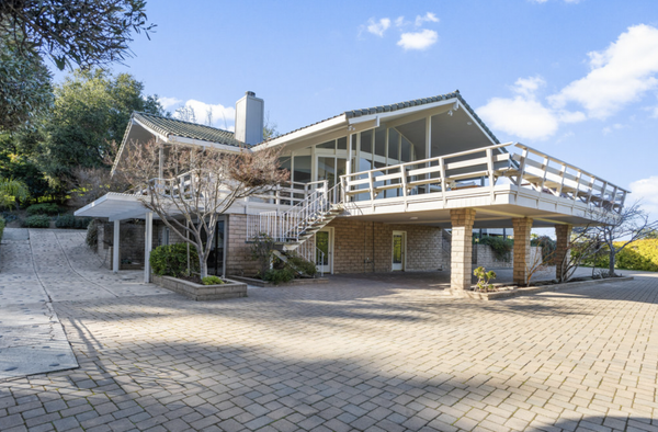
$4,700,000
Single Family Home
20932 Sarahills Dr, Saratoga, CA 95070-4838
Tucked into the coveted Saratoga foothills, 20932 Sarahills Drive embodies the perfect balance of timeless elegance and ...
Listed by Eric & Janelle Boyenga of Boyenga Team / Compass

$4,700,000
Single Family Home
20932 Sarahills DR, Saratoga, CA 95070
Stunning Gated Estate with Panoramic Views & Ultimate Privacy. Nestled in Saratogas lush hills, this extraordinary estat...
Listed by Boyenga Team of Compass

$4,700,000
Single Family Home
20932 Sarahills DR, Saratoga, CA 95070
Stunning Gated Estate with Panoramic Views & Ultimate Privacy. Nestled in Saratogas lush hills, this extraordinary estat...
Listed by Boyenga Team of Compass
MARKET TRENDS

listing detail
getting around
Getting around Saratoga
Highway 85
The West Valley Freeway (Route 85) was completed through northeast Saratoga in 1994 and has one interchange in the city, at Saratoga Avenue; exits planned at Quito Road and Prospect were never built after local objections. It links Saratoga with Cupertino and Mountain View to the north and Los Gatos and south San Jose to the east.
Highway 9 and the main roads
Highway 9 comes down from the mountains as Congress Springs Road, passes through the Village and continues to Los Gatos as Saratoga-Los Gatos Road. Saratoga-Sunnyvale Road heads north into Cupertino, Saratoga Avenue northeast toward San Jose, and Lawrence Expressway starts at Saratoga Avenue and Quito Road on the east edge.
Bus
VTA's West Valley College transit center on Fruitvale Avenue is the local hub. Line 57 runs daily via Saratoga Avenue and Westgate to Old Ironsides station in Santa Clara, and Lines 26, 37 and 51 serve the college on weekdays.
Rail
Saratoga has no passenger rail; a Union Pacific freight line runs through town beside Highway 85. From the middle of the city, Lawrence Caltrain is about 7.3 miles and Sunnyvale about 7.6 miles north, San Jose Diridon about 8 miles east, and VTA light rail's Winchester station in Campbell about 4.4 miles east (straight-line).
living here
Living in Saratoga
The Village
Big Basin Way is Saratoga's downtown and one of the main commercial areas named in the General Plan. Nearby are the 1919 Memorial Arch at Saratoga-Los Gatos Road and Saratoga Avenue, on the City's heritage inventory, and the half-acre Historical Park with three of the city's historic buildings.
Villa Montalvo
The Italian Mediterranean Revival estate built from 1912 to 1914 for James D. Phelan is now Montalvo Arts Center, open to the public with a park, hiking trails and arts programs; the mansion is on the National Register of Historic Places.
Hakone Gardens
A Japanese estate garden of about 100 years, listed among the City's parks; the City calls it one of the oldest Japanese estate, retreat and garden sites in the Western Hemisphere. Its grounds include a bamboo garden, a Zen garden, a hill-and-pond strolling garden and tea houses.
The Mountain Winery
Paul Masson's hilltop winery on Pierce Road stopped making wine in 1952 and is now a concert and events venue. It is California Historical Landmark No. 733 and is on the National Register of Historic Places.
Parks and trails
Quarry Park (64 acres) opened in 2015, and a 3.6-mile City trail built in 2019-20 links it to Sanborn County Park as the first leg of the Saratoga-to-the-Sea route, part of a long effort to connect Saratoga to the Pacific by about 37 miles of trail. On the valley floor, Joe's Trail follows the rail corridor, and Congress Springs, Kevin Moran and El Quito are the larger neighborhood parks.
Library and Heritage Orchard
The Saratoga Library on Saratoga Avenue at Fruitvale Avenue (Santa Clara County Library District) sits beside the Heritage Orchard, a City park since 1984 with plum, apricot and cherry trees and a community harvest. City Hall, the Civic Theater and West Valley College line Fruitvale Avenue next door.
your saratoga team
Buy or sell in Saratoga with the Boyenga Team
Eric and Janelle Boyenga and the Property Nerds® at Compass have sold more than 2,520 Silicon Valley homes, $2.6+ billion in all, since 1996. We know Saratoga block by block, from pricing and prep to the off-market homes most buyers never see.
Search Saratoga homes Get my home value (408) 373-1660 (650) 383-8606
how we help
Property Nerds® in Saratoga
Pricing from the data
We compare recent sales street by street, adjusting for lot, condition, schools and style, so you buy or list at a price the market will support.
Prep that pays
Selling? We focus prep money where Saratoga buyers notice it. Compass Concierge can start eligible work with nothing due upfront.
See homes first
Buying? Compass Private Exclusives and our network show you homes before they reach the public sites.
faq
Saratoga real estate FAQ
Is every 95070 address in the City of Saratoga?
No. About half of ZIP 95070's land is unincorporated county hillside, and a small east edge near Quito Road and Prospect Road is in San Jose; the El Paseo de Saratoga and Westgate centers are in San Jose too. Check the parcel's jurisdiction on county records.
Which school district serves a Saratoga address?
It depends on the address: Saratoga Union, Cupertino Union, Campbell Union or Moreland for TK-8, and Los Gatos-Saratoga Joint Union, Fremont Union or Campbell Union High for high school. Check the exact address with the district.
Does Saratoga have a train station?
No. The closest Caltrain stations are Lawrence and Sunnyvale, about 7-8 miles north of the city's center, and the nearest VTA light rail stop is Winchester station in Campbell, about 4.4 miles east (straight-line).
How old are most Saratoga homes?
County build years put about three-quarters of single-family homes in the 1950s, 1960s and 1970s, and the City's Housing Element says most of the housing stock was built before 1979. Only 211 homes were added from 2010 to 2020.
Why did Saratoga incorporate?
Residents voted in 1956 to form their own city to avoid annexation by San Jose, according to the City's history page and its General Plan.
More Property Nerd guides: Palo Alto Los Altos Redwood City Menlo Park Mountain View Cupertino Sunnyvale Los Gatos Campbell Santa Clara San Carlos Belmont San Mateo Burlingame San Francisco Atherton Los Altos Hills Monte Sereno Woodside Portola Valley San José neighborhoods Silicon Valley schools

Coming Soon
Commute Score
Coming Soon
Coming Soon
demographics
Population:
Density:
Households:
Gender
Coming Soon
Coming Soon
Coming Soon
Coming Soon

Eric & Janelle Boyenga
homes@boyenga.com